By: Ron Eguchi, ImageCAT Shanna McClain, NASA DISASTERS
“A picture is worth a thousand words,” – it’s a well-known saying, but so is, “Actions speak louder than words.” When it comes to satellite imagery, these pictures can help direct actions to manage disaster risk.
As losses caused by disasters continue to rise, investment in action to mitigate or reduce risk is critical. We cannot prevent natural hazards, but we can address the underlying drivers of risk to minimize disaster impacts. Doing so relies heavily on our ability to understand risk, which is where Earth Observation (EO) data comes in. EO data supports action to address existing risks and avoid development of new risks by managing hazard, exposure, and vulnerability.
Distribution of Fatalities per 500m2 in the 2015 Nepal Earthquake (Estimated using exposure data generated from remote sensing imagery)
Despite the obvious utility of EO data, the use of these important datasets remains limited. This disconnect comes down to the communication among imagery providers, translators, and users. There are a number of reasons why potentially valuable data go unused. Here are a few:
it’s the wrong type of data for the task at hand
visualizations don’t automatically translate to decisions
end-users are not effectively trained in the use of the data, and therefore, do not know how to integrate these new datasets into existing workflows
So how do we get from imagery to action? To overcome these challenges, an important dialogue must be established among involved stakeholders: (1) providers of imagery, e.g., NASA, commercial satellite companies like DigitalGlobe, (2) the translators who produce pre- and post-disaster products (risk modeling companies, research organizations, universities), and (3) the users of this information (first responders, field engineers, NGOs, search & rescue teams, etc.).
High resolution satellite imagery was previously only available to government agencies (mostly military), but now it has become readily accessible to the public and to commercial entities that use it to create derived products. This recent change has resulted in a rapid expansion in the number of use cases for EO data, which might explain why providers, translators, and users are still working out how to communicate with each other.
Earth Observation Global Exposure Data (left) and GRUMP urban area (right)
EO data is a resource for quantifying community risk and visualizing the interconnectedness of populations, key infrastructure, and climate-related processes. Through high-resolution optical imagery and active sensors, remote sensing technologies enable disaster risk managers to quantify pre-disaster vulnerabilities as well as post-disaster damage. Remote sensing is also used to monitor recovery and reconstruction after significant disasters. More recently, it was used to develop exposure information for urban infrastructure.
Investing in risk mitigation before disasters occur is key to reversing the trend of ever-increasing losses from disasters, which are especially devastating in developing countries. The past several years have brought research and application of EO imagery to delineate areas of urban development as well as the locations of critical infrastructure, e.g., roads, highways, bridges. Using a variety of satellite sensors in combination with locally collected data (including global census data), researchers have been able to construct inventories of buildings with regional profiles of building construction type, size, and occupancy. Based on this information, analysts quantify the expected damage or loss to communities from a wide range of natural hazards. Risk profiles make it possible for in-country policy makers to consider systematically how best to address risks for both urban and rural settings.
Where do we go from here? Let’s talk about it
In our technical session at the 2018 Understanding Risk Forum, we will bring together international leaders in disaster risk communication and management with the technologists and scientists who generate EO-based products in an exercise to drive the dialogue forward – from data to decisions.
The session will walk participants through a scenario and place imagery from past disasters and post-disaster impacts into the hands of the decision makers. The goal is two-way communication of common challenges and opportunities for identifying and reducing future risk. In addition to this exercise, a panel of experts will provide various perspectives on how EO-based imagery can be better packaged to more effectively address issues in risk reduction and resilience. To set up the exercise, we will leverage fresh ideas from the URInterdisciplinary Pressure Cooker, which will bring together 30 youth from around the world to practice time sensitive risk communication. We will be especially interested in the role – perceived and/or actual – that technologies play in risk reduction and resilience enhancement.
By Christopher Wieczorek, Harold Magistrale and Thomas Roche of FM Global
Resilience, in its highest form, entails the elusive ability to prevent disasters from cascading. Can your business, industry, community, or nation contain a disaster as a solitary “domino”? Or will a single event trigger a cascade of human and economic setbacks?
Resilience, the ability to resist and rebound quickly after a disaster, requires avoiding any effect of a disaster that is preventable so that a disaster ends after it has wreaked only the destruction that was inevitable. As the title of our Understanding Risk technical session indicates (Understanding Cascading Events: Earth, Wind and Fire), we will closely examine how disasters cascade and the tremendous resulting costs. This understanding will help participants develop more effective strategies to minimize these cascading effects, calculate the costs and benefits of investing in resilience, and plan for successful rebounds.
What does a cascading disaster look like?
Imagine you are a manufacturer of cell phone components containing rare earth elements and have a warehouse filled with delicate and expensive parts. The warehouse is warmed by a gas-powered space heater. An earthquake strikes. The ground shakes. The walls tremble, but the building remains standing. Carefully stacked parts wobble on the shelves, but none fall.
However, the rigid gas line breaks. The space heater, now disconnected from the gas main, topples to the ground, igniting a fire that burns down the warehouse. The earthquake was inevitable but the gas line break was not. That’s where inevitability ends. The fire didn’t have to occur. It was cascading effect number one, the first of many.
The stored electronics were lost in the fire, so you incur tremendous cost in doubling back to mine new raw materials, process them into useful alloys, and fabricate them into replacement components. There is also an environmental cost to the mining, and a political cost given the ecological value of the minerals. Because the components were destroyed, business operations ceased for weeks. That means OEMs are angry, and revenue has dried up. More resilient competitors are seizing your market share.
On the local level, your employees struggle with the earthquake’s impact on their homes and families. Their place of work has been destroyed, displacing them to another facility, necessitating additional travel and difficult working conditions. Some may take another job closer to home. Some of these costs, e.g. the loss of your market share and valuable employees, may constitute irreversible damage.
What resilience looks like
The simple alternative in this scenario? A gas line with a flexible connection and an automatic seismic shutoff valve in a warehouse fully equipped with automatic sprinklers.
The cost of installing these parts would have been a tiny fraction of the cost of the cascading events. Resilience was possible with the help of a modest plumbing job. Skipping that investment resulted in profound damage.
We’ve seen real-life scenarios that look very similar to the warehouse hypothetical example, except that they affected entire industries. Floods and earthquakes have disrupted computing and automotive supply chains, with cascading effects constituting existential crises for affected businesses. Although we have learned from these disasters, we nonetheless see cascading effects waiting to happen. One example of this would be new construction in flood-prone areas.
Digging deeper
Given that disasters wreak billions in global economic losses, it is critical to know before a disaster strikes what it would cost in lives and dollars, and which costs can be avoided by minimizing the cascading effects of a disaster. We invite you to join us in exploring these important concepts at the 2018 Understanding Risk Forum. We promise a lively, interactive session. We will examine six key dimensions of a nation’s resilience in the face of cascading events such as hurricanes, earthquakes, fires and floods:
People
Community
Supply chain
Environment
Operations
Investment
We will also present three different real-life disaster scenarios. Participants will map out how the disaster scenarios might unfold, and generate ideas about how before-the-fact investments could have mitigated the likely cascade. We will discuss, debate and learn together to deeply understand the risk of cascading disasters – and get closer to our goal of resilience.
We live in an age of compounding uncertainty. The unpredictable impacts of climate change and the rapid urbanization of societies is increasing the complexity, difficulty, and necessity of making sound decisions when faced with numerous options. This uncertainty is acute with respect to natural disasters – for example, predicting hurricane intensity or locating the next big earthquake remain challenging tasks despite advances in science and monitoring tools.
Volcán de Fuego in Guatemala, one of Central America’s most active volcanos, spews ash and lava flows in January 2018, just 70 kilometers west of Guatemala City. Image: NASA
The challenge of anticipating and communicating the risk of volcanic eruptions to communities requires complex decision-making. Ecuador’s Cotopaxi Volcano and Indonesia’s Mount Agung are recent examples where the warning signs were present (small earthquakes, increasing gas emissions, and more), yet an eruption came much later than expected. Volcanic eruptions are therefore a double-edged sword that often creates a decision-making dilemma. While signs of volcanic activity can provide adequate time for preparation and evacuation, the very same signs can also create conditions of extreme uncertainty, which can be exacerbated by piecemeal communication around eruption events.
So, what have we learned from recent experiences on the challenges of communicating volcanic risk?
While largely unpredictable, volcanic eruptions are devastating and can change the course of humanity. Over the last 11,500 years, more than 1,500 major eruptions have occurred, with approximately 500 in the Pacific “Ring of Fire” alone. We don’t have to look far back in history to find examples of devastating volcanic eruptions. The instantaneous destruction of Pompeii by Mt. Vesuvius is perhaps the most oft-cited event, but a more devastating, less remembered event is the 1815 Mount Tambora eruptionin Indonesia. The “Pompeii of the East” claimed the lives of more than 70,000 people. Mt. Tambora’s ash fallout led to climate anomaliesthroughout Europe and North America for years afterward, causing the century’s worst famine. Dozens more recent eruptions have claimed tens of thousands of lives and caused billions of dollars in economic losses, including: El Chichon (Mexico); Nevada del Ruiz (Colombia); Mt. Pinatubo (Philippines); Mt. Etna (Italy); and Iceland’s Eyjafjallajökull.
Communicating risk for volcanic eruptions on a timely basis is not straightforward.Though the science of volcanic eruption forecasting has come a long way in recent decades, accurately predicting volcanic eruptions and communicating uncertainty to highly exposed communities is fraught with difficulties and can quickly become ineffective. For example, communities may risk not evacuating, or wait for clear communication that a volcano is likely to erupt when it’s already too late to evacuate. While volcanology offers a wide range of measurements that can indicate if and when an eruption will occur, timely decisions still need to be taken by experts regarding when to publicly sound the alarm.
Decision-making paralysis can prove fatal for vulnerable communities. Now that increasingly dense human populations span the globe, today’s level of exposure to volcanic risk is unprecedented. More than one billion people live within 150 kilometers of an active volcano, with major cities like Tokyo, Naples, Manila, or Managua ranking among the most vulnerable to their impacts – eruptions which could cost large cities up to $30 billion. Unaware of the danger or overwhelmed by the looming decision, governments tend to become paralyzed into the least helpful course of action – doing nothing.Given that large-scale evacuations require tremendous resources and have ripple effects on economic activity, should governments err on the side of caution, or preparedness?
Deciding how to deal with risk is an inherently political process, and our decisions have serious and lasting consequences, including for potential volcano eruptions. But informational complexity and compounding uncertainty should not dissuade us from taking action to ensure the safety and prosperity of communities. The way forward, among many possible courses of action, will not simply be discovered – it must be created.
How should we communicate such complex information to at-risk communities and decision makers who have not seen a volcanic eruption in their lifetime?
How can we ensure that volcano eruptions are routinely considered alongside all the other risks that countries face?
To delve into these questions and others, the University of Plymouth, GFDRR, and the World Bank are hosting a dedicated session at the 2018 Understanding Risk Forum in Mexico City on May 17, 2018. As we focus on the specter of volcanos, we will also consider how our discussion and conclusions might be of value to those faced with climate change uncertainty, rapid urbanization, and other concerns closely related to volcano risk.
We hope you will join the conversation with the session moderator, Professor Iain Stewart either in Mexico City at UR2018 or via Twitter.
Submit your questions ahead of the event by tweeting at @UnderstandRisk using #URVolcanos. We’ll answer them online and live during the session.
The future is uncertain. It’s hard to know exactly how our climate will change. That means there is also deep uncertainty around its impacts on flooding, the most prevalent disaster worldwide. Floods account for 43% of all recorded disaster events in the past 20 years. Will climate change exacerbate flooding events? How much will sea level rise? How extreme will rainfall be?
What we do know is that the best way to cope with uncertainty is flexibility.
While it may be difficult to predict impacts, we can–and must–take action. Growing uncertainty means preparation is even more urgent. To meet future challenges, we need adaptable urban flood management today.
Most flood management actions tend to be large, costly investments that have lasting consequences for society, such as the construction of enormous dams and dredging of drainage channels. Additionally, flood management plans are typically crafted to operate within a narrow range of conditions. This traditional approach to flood management – based on the assumption of a more-or-less stationary climate – is quickly losing ground. We need robust and flexible measures to deal with urban floods.
Coupled with the dynamic nature of cities and societies, climate uncertainties complicate flood management decisions. The best way to deal with uncertainty is to master the art of flexibility — developing measures and flood defenses that can evolve over time — to prepare for a wide range of plausible outcomes from the start.
Several approaches and tools have emerged in recent years to better support decision-making under conditions of deep uncertainty. One such approach is the Dynamic Adaptive Policy Pathways (DAPP) approach, which supports the development of an urban flood management plan that can deal with conditions of deep uncertainty.
What is an ‘adaptive pathway approach’?
As the saying goes, “All roads lead to Rome.” The basic idea behind adaptive planning is to generate a wide array of ‘pathways’ through which policy objectives are achieved under changing climate and socio-economic conditions. Three key elements are central to the adaptation pathways concept:
responses to changes that are effective under the widest set of all plausible future scenarios
responses do not foreclose future options or unnecessarily constrain future choice
relevant changes are foreseen through targeted monitoring and scenarios of the future are continuously being reassessed
Mapping possible ‘pathways’ allows users to plan a journey towards sustainable urban flood management by exploring multiple routes alongside each other, all while considering costs and consequences. Each adaptation pathway consists of a series of actions. If circumstances change along the way, you can change your route by switching or adding actions so that you ultimately achieve your goal.
Pathways differ according to the actions involved, their resulting benefits, and the required investments. Some pathways are more robust, while others are flexible. The ultimate choice depends on the stakeholder preference and the resources available.
Figure 1: The Dynamic Adaptive Policy Pathways (DAPP) approach
The different options have one thing in common: Each pathway results in an urban flood management strategy that is effective at any point in time between now and the distant future. This approach allows us to plan without running the risk of regret of doing too little too late or too much too early. Figure 1 illustrates the different steps in the DAPP approach.
How has this approach been applied?
The Netherlands Delta Program is a good example of how the Dutch adopted an adaptive approach towards flood management. They shifted from a basic ‘predict and act’ system to one that involves anticipating the future and adapting as circumstances change. Figure 2 shows the adaptive pathway map that has been developed for the city of Rotterdam in order to identify the best flood management actions to pursue at different time stages.
Figure 2: Adaptation pathway map for flood risk management in the Rotterdam area (Delta Programme 2014)
Managing flood risk in Thames Estuary, UK – In the UK, the use of adaptation pathways was pioneered by the Thames Estuary 2100 (TE2100) project which produced a plan for managing tidal flood risk in the Thames estuary and London. The TE2100 plan has a set of options for adaptation pathways (see Figure 3) that can cope with increases in maximum water levels up to a worst-case scenario by 2100. The preferred pathway identified is structured as a staged long-term modification of the Thames Barrier combined with local measures to manage fluvial and pluvial flooding – including making space for water, local flood defenses, building resilience measures, flood forecasting, and emergency planning. TE2100 sets a long-term strategic vision for how London can adapt, and establishes the need for transformational change in the long term.
Figure 3: Adaptation pathway map for the Thames Estuary – shows the high-level adaptation options and pathways developed by TE2100 (y-axis) relative to threshold level increase in extreme water level (x-axis). The light blue line illustrates a possible ‘route’ where a decision maker would initially follow HLO2, then switch to HLO4 if sea level were to increase faster than predicted.
Curious to learn to use the DAPP approach and Adaptation Pathway Mapping tool? Join the 2018 Understanding Risk Forum technical session: Assessing Urban Flood Risk: Going with the Flow. In this session, we will facilitate dynamic discussions and interactive activities to show how this approach works and demonstrate its applicability in different cities.
Come and join us on the journey toward sustainable urban flood management!
Acknowledgements: ‘Go with the flow – An adaptive approach to managing flood risk’ technical session is jointly organized by the Urban Flood Community of Practice (UFCOP) and NUSDeltares.
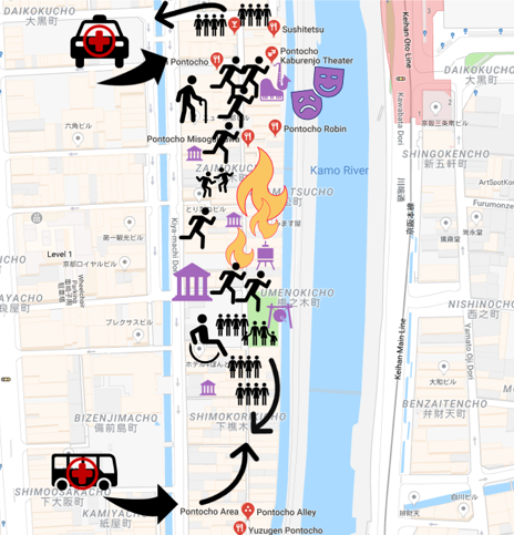
It is 7:45 pm in Ponto-cho, the historic narrow alley at the core of the Japanese city of Kyoto. Close to the Kaburenjo Theater—where still today Geikos and Maikos (Kyoto Geishas) practice their dances and performances—the traditional adjoining buildings with restaurants and shops are full of guests. Local people, tourists, students… On this Saturday in mid-April, the warm weather brings a lot of people to the streets nearby.
At 7:46 pm, a M 5.1 earthquake strikes. Seven seconds of swaying. It doesn’t cause major damage, but it is enough to spread panic among a group of tourists. Screams, shoving, confusion … drinks spill, candles fall, people rush.
At 7:49 pm, the fire starts spreading through the old wooden structures, also threatening the historic theater. Access is difficult due to the narrow streets and panicking crowd.
What happens next?
It could be a fire in the Ponto-cho traditional alley. It could be an earthquake shaking the historic center of Kathmandu (Nepal), the archaeological site of Bagan (Myanmar), or the historic town of Amatrice (Italy). It could be Typhoon Haiyan in the Philippines or Hurricane Irma in the Caribbean, blasting sites with rain, flooding, and gale-force winds.
Cultural heritage assets around the world are at risk. They are often vulnerable due to their age, as well as previous interventions and restorations made without disaster risk or overall site stability in mind. Heritage sites reflect legacies, traditions, and identities. With all this, they carry a large cultural and emotional value of what could be lost – certainly beyond the traditional calculus of economic losses.
In many cases, it is not possible or advisable to conduct reconstruction on cultural heritage sites post-disaster. Therefore, the essence and soul of a cultural heritage site is at risk of being lost forever, making preparedness and preservation even more critical.
How can we protect these special places and traditions from the threat of natural hazards?
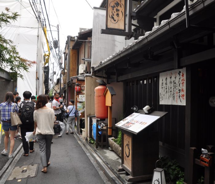
Ponto-cho restaurant affected by fire on 2016 (left) and Ponto-cho from the river area (BMG, 2016)
A disaster risk management approach can be fundamental for preserving heritage sites and –along with them– our human histories. Since such sites are often tourist destinations, frequented by people who are unfamiliar with the area, comprehensive risk assessment and preparation can save lives. Unfortunately, there is often a gap in awareness and understanding of disaster risk –among site managers, surrounding communities, and the visiting public, including tourists and pilgrims.
The first step is to understand the risk –to the physical monuments and the integrity of the site, the cultural and economic activity in and around the site, and the well-being of local people and communities. To do this well, the local community –living and working nearby– must be part of the process to identify the risks and then protect and preserve the site, its character, and its integrity.
This is not easy. We do not tend to see or even look for risk around our regular places of work or homes. Even more complicated is communicating risk to others who may only be indirectly affected, such as government officials and decision makers.
Interactive activities like the Disaster Imagination Game (DIG) can help communities—including neighbors, local authorities, and heritage specialists—to understand and communicate risk. This methodology, developed in Japan, brings together different stakeholders from a historic area to analyze and assess the situation, and then prepare people and places to face possible disasters. Ultimately, they discuss and decide upon potential solutions to avoid or mitigate risk, along with preparedness measures and plans for emergency response.
This exercise asks participants to reflect on key questions related to a specific cultural heritage risk scenario. For instance, consider the following about your hometown or a place you know well:
What and and where are the cultural heritage assets located? Are they structures, or are there also movable assets (e.g. Museum artifacts)? Why are they important?
Are there emergency evacuation routes for people at these sites? How about alternative evacuation routes to access and rescue critical heritage?
Are you aware of the natural hazards in the area? How about secondary, or cascading, hazards? (e.g. fires started after an earthquake) How could those hazards affect the heritage?
Who makes up the community in the area? Are there elders or people with disabilities? Are there usually many tourists or visitors from out of town?
Which are, therefore, the main potential risks to the heritage sites and artifacts? Which measures could or would mitigate those risks?
Interested in how communities are addressing this challenge around the world? Don’t miss this #UR2018 session:
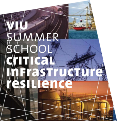
In this second edition, we bring together academics and professional experts to discuss an emerging topic with a pragmatic and scientific approach. The program is primarily designed for working professionals and graduate students with an interest in engineering, economics, governance and/or risk management. But the concepts and tools apply to all fields.
The School explains how critical infrastructure works and fails; its cascading impact from local to global, and the strategies to use to build a resilient society. The course will discuss the concept of CI and the EU framework, and present a series of tools and solutions for resilience. The participants will gain (i) a clear understanding of the key concepts, (ii) a methodology to apply it to their specific field/scale, and (iii) an overview of specific tools and solutions from recent applications. The course consists of a mix of theoretical knowledge, case studies/projects and hands-on exercises. The beautiful city of Venice is an ideal setting that participants can use to identify critical infrastructure, assess its risk, and develop resilience strategies.
The call for application is now open, until March 29, 2018. For more information, please visit:

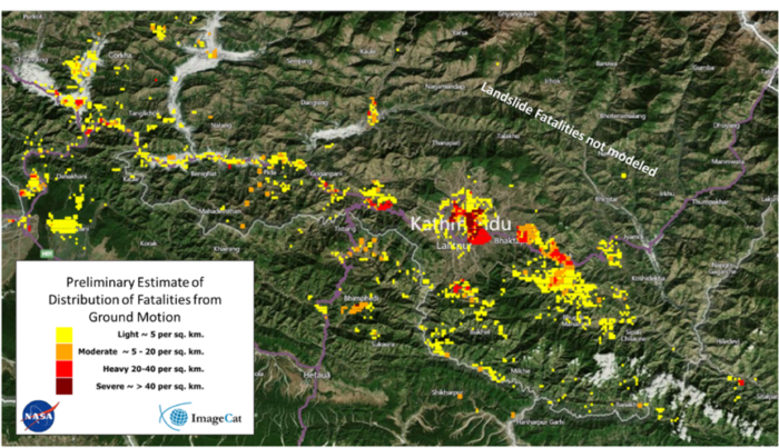
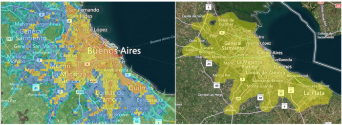


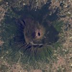
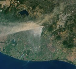
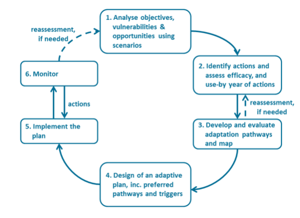
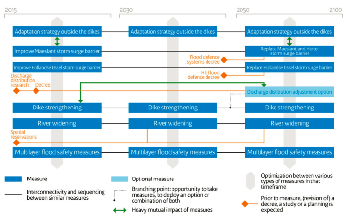
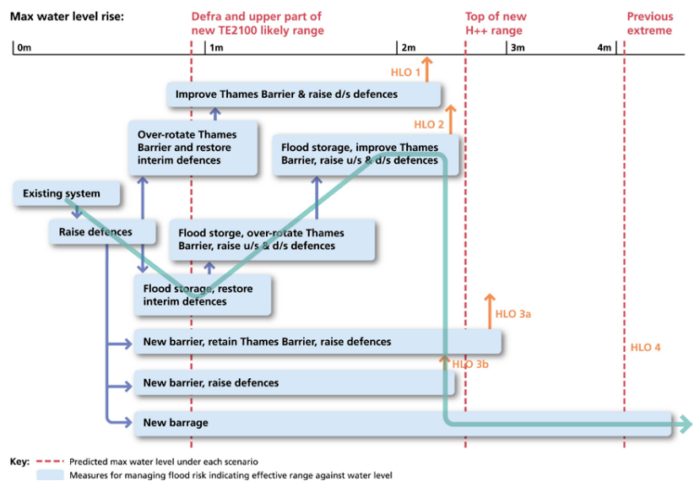
 photo: Barbara Minguez Garcia, 2016